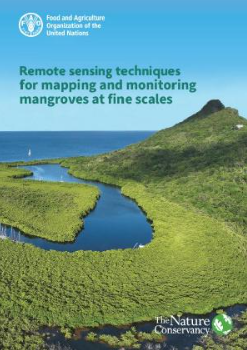
Mangrove ecosystems play a critical role in harbouring biodiversity and providing a variety of ecosystem services. The need for developing better techniques for classifying and monitoring mangroves is increasing, especially with the growing demand in blue carbon markets. However, many countries are challenged by the need to improve their mangrove cover estimates to inform decision-making on coastal land use and to guide local conservation efforts including restoration planning. This manual was developed to help overcome this problem by providing guidance, specifically targeted to build capacity for mangrove resource managers on how to use and take advantage of the latest technologies in mapping and monitoring mangroves. It enables collection of data that informs conservation decision-making, guiding the planning of mangrove restoration and protection activities that will ultimately lead to enhanced management and conservation of mangroves. In addition, case studies are presented on estimating mangrove extent, structure, condition and change, using a range of remote sensing-derived sources that are focused on < 5-m spatial resolution.
Aligning climate-smart marine spatial planning and ecoscape restoration for global biodiversity recovery
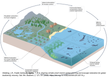
Meeting the ambitious targets set by the Convention on Biological Diversity (CBD) Kunming-Montreal Global Biodiversity Framework (GBF) will require expanding ecosystem restoration across governance domains for marine and coastal ecosystems.
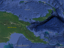
An Assessment of Marine Turtle Exploitation in Papua New Guinea
In the early 1980s Spring’s report on marine turtle species distribution indicated there were 6 species of turtles that could be found in PNG water including the green, hawksbill, leatherback, loggerhead, olive ridley and the flatback turtles.
An international assessment of the barriers influencing the effectiveness of island ecosystem management
Island ecosystems are disproportionally impacted by biodiversity loss and as such their effective management is critical to global conservation efforts.
An Introduction to the MPA guide

The Marine Protected Area (MPA) Guide refines existing language and captures a shared vision to describe MPAs and the conservation outcomes they provide. The Guide is the work of many hundreds of stakeholders from around the world.
Ants need urgent protections from global trade, conservationists say

As the recent seizure of more than 5,000 endemic ants in Kenya reveals, ants have become part of a thriving global wildlife trade. Transnational traffickers are mopping up ants from the wild to sell them to hobbyists and collectors worldwide.
Assessing Protected Area Management Effectiveness
The Nature Conservancy. Assessing Protected Area Management Effectiveness. Convention on Biological Diversity and World Wildlife Fund for Nature Conservation. 2008
Assessing the quantity and quality of marine protected areas in the Mariana Islands
Marine protected areas (MPAs) are ubiquitous in global ocean conservation and play a pivotal role in achieving local, national, and regional area-based conservation targets.
Assessment of management effectiveness for PNG's protected areas 2017
This is the final report prepared by the Secretariat of the Pacific Regional Environment Programme (SPREP) for submission to the United Nations Development Programme (UNDP) and the Papua New Guinea Conservation and Environment Protection Authority (CEPA) in relation to the 2016–17 assessment of t
Assessment of Target and Non-target Species catch rates in the Kikori Fish maw Fishery and Local Ecological Knowledge of locally Threatened Dolphin Species.
This report shares the findings of a study aimed at providing information to fisheries managers on the rate of by-catch and use of different species in the growing ‘fish maw” industry in Papua New Guinea’s Kikori Delta.
Assessment tool addresses implementation challenges of ecosystem-based management principles in marine spatial planning processes
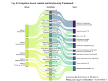
Ecosystem-based marine spatial planning is an approach to managing maritime activities while ensuring human well-being and biodiversity conservation as key pillars for sustainable development.
Bamboo Bay Community Turtle Management Plan.
Bamboo Bay is an important turtle nesting site in Malekula especially for green and hawksbill turtles. The community has been monitoring and conserving turtles, their nests and hatchlings since the 1990s.
Barriers to volunteering and other challenges facing community-based conservation in Aotearoa New Zealand
In many countries, community-based conservation plays an important role in protecting natural ecosystems and preserving biodiversity.
Baseline survey of Maninita island, Vava'u, Kingdom of Tonga: preliminary report
Maninita, the southernmost island of the Vava'u group is an important seabird nesting site and a proposed national protected area as originally identified by the Government of Tonga's Ministry of Lands, Survey and Natural Resources.
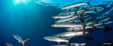
Bending back the curve of shark and ray biodiversity loss
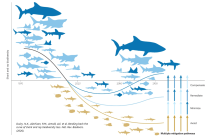
Sharks and rays are sentinels of the state of the ocean. Since the mid-twentieth century, overall abundance has declined by nearly 65% and over one-third (37.5%) of species are threatened, causing widespread changes in community structure.
BEST AVAILABLE TECHNOLOGY (BAT) AND BEST ENVIRONMENTAL PRACTICE (BEP) FOR MITIGATING THREE NOISE SOURCES: SHIPPING, SEISMIC AIRGUN SURVEYS, AND PILE DRIVING
At least 150 marine species have shown impacts from ocean noise pollution, but it has been difficult to specify the exact scenarios where ecosystem and population consequences from underwater noise will occur. Therefore, managing this threat requires a precautionary approach.
Best Practice in Delivering the 30x30 Target
This guidance document identifies the best options for successful delivery of draft Target 3 of the Global Biodiversity Framework (GBF) from the Convention on Biological Diversity (CBD). There is good evidence that this will radically increase the success of biodiversity conservation.
BEYOND CARBON CREDITS: DEMYSTIFYING NON-CARBON MARKET APPROACHES FOR BLUE CARBON ECOSYSTEMS Deep-Dive Report for Practitioners and Policymakers
The conservation, restoration, and sustainable management of blue carbon ecosystems are critical to addressing the intertwined crises of climate change and biodiversity loss.
Beyond deforestation: redesigning how we protect and value tropical forests (analysis)
Heading into COP30, where tropical forests are set to be a central theme, it seemed worth looking today’s trajectories a little further forward and imagine where they might lead. Part 1 looked at possible fates of tropical forests.
Biodiversity and biogeography of zooxanthellate soft corals across the Indo-Pacific
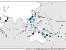
Documentation of biodiversity and its geographical distribution is necessary to understand the processes and drivers of evolutionary diversification as well as to guide conservation and management initiatives.
Biodiversity and Protected Areas
Protected areas are key to biodiversity conservation. While the value of protected areas is generally undisputed, challenges remain.
Biodiversity bonds can work, but their design flaws must be fixed (commentary)
The interlinked crises of climate change and biodiversity loss are slipping down political agendas just as geopolitical instability and fiscal pressures rise.
Biodiversity conservation requires integration of species-centric and process-based strategies
Conservation science and policy are geared primarily toward the preservation of species and habitats, with priority often given to the rarest, most vulnerable or most charismatic forms.
Biodiversity needs every tool in the box: use OECMs
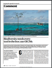
Global support is growing for the 30 × 30 movement — a goal to conserve 30% of the planet by 2030. In May, the G7 group of wealthy nations endorsed the commitment to this target that had been made by more than 50 countries in January.
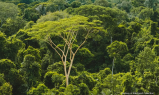
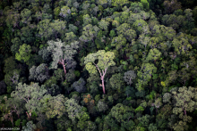
Biodiversity resilience in a tropical rainforest
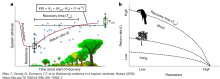
The UN Decade on Ecosystem Restoration aims to stop biodiversity losses1. Approximately 60% of tropical forests have already been lost or severely degraded2, making restoration essential to achieve conservation goals.
Biology and Impacts of Pacific Island Invasive Species. 17. Lissachatina fulica, the Giant African Snail (Mollusca: Achatinidae; Achatininae)
We review the taxonomy, biology, and the ecological, economic, and human health impacts of the giant African snail, Lissachatina fulica, in the Pacific. Invasion of L. fulica in the Pacific has a complex history. Rapid population expansions of L.
Biophysically Special, Unique Marine Areas of Solomon Islands
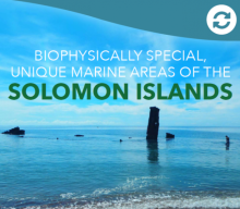
In April 2016, the Cabinet of the Solomon Islands Government endorsed the establishment of the Ocean12 National Steering Committee (comprising the twelve Ministries relevant to ocean management and use) with the mandate to progress Integrated Ocean Governance for the Solomon Islands.
Biophysically Special, Unique Marine Areas of Tonga
In 2015, the Tongan Cabinet embarked upon a National Marine Spatial Planning process, establishing a marine spatial planning technical working group comprising seven Ministries (the “Ocean 7”). One of their tasks was to identify Tonga’s special, unique marine areas.
Biophysically Special, Unique Marine Areas of Vanuatu
In 2014, the Vanuatu Council of Ministers (Decision No. 172/2014) supported the development of a national ocean policy and marine spatial plan, and in doing so, established an Ocean Policy Subcommittee to guide these processes.
Biophysically Special, Unique Marines Areas of Fiji
Fiji is committed to, and is embarking upon, a process to significantly increase the number and coverage of Marine Protected Areas (MPAs) within the country.
BioTIME hourglass logo BioTIME

BioTIME is designed especially for scientific synthesis studies with research questions about global biodiversity. We believe that data is valuable and should be made usable.
Birds and bats reduce herbivory damage in Papua New Guinean highland forests
Insectivorous predators, including birds and bats, play crucial roles in trophic cascades.
Blue Carbon Ecosystems of the South Pacific: Ecosystem Assessments in Fiji, Papua New Guinea, Solomon Islands, and Vanuatu
The project contributes to the Secretariat of the Pacific Regional Environment Programme (SPREP)’s component of the Management and Conservation of Blue Carbon Ecosystems (or MACBLUE) project, aiming to “contribute to human and technical capacity to the mapping, management and rehabilitation of co
Blue Carbon Ecosystems of the South Pacific: Field-Based Carbon Assessments in Fiji, Papua New Guinea, Solomon Islands, and Vanuatu
The project contributes to the Secretariat of the Pacific Regional Environment Programme (SPREP)’s component of the
Management and Conservation of Blue Carbon Ecosystems (or MACBLUE) project, aiming to “contribute to human and
Blue Carbon Finance Toolbox
The Blue Carbon Finance Toolbox aims to provide the global blue carbon community with an overall guide to understanding and leveraging finance mechanisms that
Blue Carbon Finance Toolbox First edition: June 2025
The Blue Carbon Finance Toolbox provides a comprehensive overview of financial mechanisms and strategies to support the conservation,  
Blue Prosperity Vanuatu 2023 Coral Reef Study Preliminary Science Report
From 1-21 September 2023, the Government of Vanuatu, in partnership with Blue Prosperity Vanuatu, local NGOs, and international collaborators, conducted the largest nationwide coral reef study across all six (6) provinces of Vanuatu.
Blue Prosperity Vanuatu FINAL SCIENCE REPORT
From 1–21 September 2023, the Government of Vanuatu, in partnership with the Waitt Institute through Blue Prosperity Vanuatu, conducted the most extensive coral reef survey in the nation’s history.
Businesses and Biodiversity: New opportunities with Other Effective Area-Based Conservation Measures (OECMs)
The loss of biodiversity is accelerating globally, and there is growing recognition that both halting and reversing this loss requires action from all of society, in addition to governments, civil society organisations, Indigenous peoples, local communities and the private sector.
Calm seas can drive coral bleaching, research reveals
New research by Monash University and the ARC Center of Excellence for the Weather of the 21st Century analyzed close to three decades of weather data during the coral bleaching season and identified the prevalence of "doldrum days," and the absence of the trade winds, as a key factor in the mass
Can the ocean heal?
The common interest in healthy fish stocks means that solutions must involve support from conservationists, scientists and fishers.
Capacity Development for Protected and Other Conserved Areas in the Pacific Islands Region
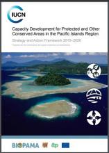
This document is an important tool for promoting action. It highlights the importance of culturally‐responsive capacity development, with Pacific Islanders defining the most appropriate approaches to be used.
Capacity for Conservation
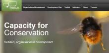
Capacity for Conservation relates to organisational ability to deliver effective protected area management. Operated by several conservation organisations, Capacity for Conservation believes that building strong conservation organisations is one of the most effective means of making a lasti
Catchment Management and Restoration Plan for Rarotonga Cloud Forest Ecosystems, Cook Islands
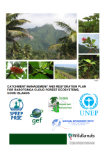
This document provides a plan to protect and enhance the cloud forests of Rarotonga so that their indigenous ecosystems, habitats for endemic species, and water supply functions are preserved in perpetuity.
Challenges and opportunities integrating remote sensing for mangrove conservation in Papua New Guinea's complex natural and human landscapes.
Papua New Guinea (PNG) is home to one of the largest mangrove habitats (6% of the world’s mangrove area), which plays a crucial role in coastal protection, carbon sequestration and supporting biodiversity and livelihoods.
Charting the course for management: a global analysis of effects of vessels on marine megafauna
Vessel traffic represents one of the most pervasive and escalating sources of disturbance in marine environments, affecting organisms through noise, physical presence, habitat degradation, collisions, and pollution.
CITES Sharks and Rays - Implementing and Enforcing Listings: Volume II - Processed Carcass ID
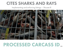
This guide forms part of a three-volume series of identification guides: Volume I – Full Carcass ID, Volume II – Processed Carcass ID [this guide], and Volume III – Dried Product ID.
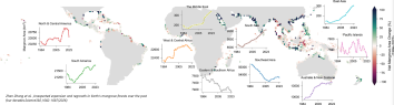
Climate change is driving fish stocks from countries’ waters to the high seas: Study
Fish and other marine organisms, though deeply affected by human activities, don’t respect human borders. The ranges of many commercially important species in fact straddle the borders of countries’ exclusive economic zones (EEZs) and international waters, known as the high seas.
Climate Change, Coral Reef Ecosystems, and Management Options for Marine Protected Areas
Marine protected areas (MPAs) provide place-based management of marine ecosystems through various degrees and types of protective actions.