  • SPREP Home
  • Protected Areas
SPREP Home
Log in
Search
Home | PIPAP - Supporting the sustainable management of protected areas in the Pacific Region.
  • Data
    • Protected Areas
    • Management Effectiveness Dashboard
    • Spatial Data
  • Assistance
    • How SPREP Helps
    • WDPA Protected Area Registration
    • Protected Area Working Group
  • Resource Hub
    • Publications
    • Decision Making Support Tools
    • Case Studies
  • Newsletter
    • Browse Newsletter Archive
    • Subscribe Now
  • Account
    • Login

Main menu

  • Data
  • Assistance
  • Resource Hub
  • Newsletter
  • Account

Breadcrumb

Home

The new double-sided projection by Gott, Goldberg and Vanderbei. Credit -
A new world map projection minimises the inherent problems of flattening the globe
April 22, 2021

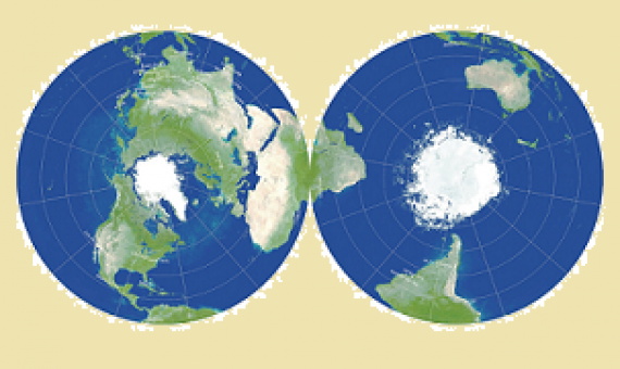
The problem of how to depict the curved surface of the Earth on a flat map has troubled cartographers for centuries. There are many ways of doing it, but they all have downsides. Take one of the most famous: the cylindrical Mercator projection, used by Google Maps.

  • Read more about A new world map projection minimises the inherent problems of flattening the globe
The Arizona State University Global Airborne Observatory on a mapping mission over North Maui Island coast. Credit: Center for Global Discovery and Conservation Science
Mapping corals from the sky guides reef conservation
December 16, 2020

Coral reefs are one of the most biodiverse ecosystems on the planet supporting an estimated 25 percent of all marine species.

  • Read more about Mapping corals from the sky guides reef conservation
Visual comparisons of a map by the United Nations Environment Program World Conservation Monitoring Centre (UNEP-WCMC), the leading global coral reef map, and the GDCS coral reef extent map in different regions, including (a) Great Barrier Reef (GBR), Australia, Papua New Guinea, Indonesia; (b) Madagascar, East Africa; (c) Red Sea, Samoa, Virgin Islands. Credit: Center for Global Discovery and Conservation Science at Arizona State University
Location and extent of coral reefs mapped worldwide using advanced AI
October 29, 2020

Nearly 75% of the world's coral reefs are under threat from global stressors such as climate change and local stressors such as overfishing and coastal development.

  • Read more about Location and extent of coral reefs mapped worldwide using advanced AI
Poyang Lake. Credit: European Commission, Joint Research Centre (JRC)
First-of-its-kind surface water Atlas brings together 35 years of satellite data
October 28, 2020

The Atlas of Global Surface Water Dynamics created by the European Commission's Joint Research Center (JRC) illustrates the changes in the Earth's lakes, rivers and wetlands over time.

  • Read more about First-of-its-kind surface water Atlas brings together 35 years of satellite data
Satellites could soon map every tree on Earth
October 16, 2020

Terrestrial ecosystems are defined in large part by their woody plants.

  • Read more about Satellites could soon map every tree on Earth
RMI virtual training images. Credit - SPREP
Virtually Enhancing Marshall Islands Protected Areas With GIS And Site Mapping Skills
August 27, 2020

Protected area practitioners and stakeholders of the Republic of the Marshall Islands (RMI) are now equipped with the skills to produce basic maps of protected and conserved areas following an online, virtually delivered training on the upgraded tools and features of the Pacific Islands Prot

  • Read more about Virtually Enhancing Marshall Islands Protected Areas With GIS And Site Mapping Skills
An image depicting the latest bathymetric mapping of the world’s ocean sea floor. The coloured areas show mapped areas, while the black sections show areas that remain unmapped. (Credit: The Nippon Foundation-GEBCO Seabed 2030 Project)
Scientists have now mapped one-fifth of world's ocean floor
June 26, 2020

A group of scientists has successfully mapped one-fifth of the world’s ocean floor, a significant milestone for the team on its mission to measure every depth and recess of the planet's seabed by the end of the decade.​ With about 71 per cent of our planet’

  • Read more about Scientists have now mapped one-fifth of world's ocean floor
NOAA, Schmidt Ocean Institute team to explore and map the ocean. Courtesy of Schmidt Ocean Institute
NOAA, Schmidt Ocean Institute team to explore and map the ocean
June 11, 2020

NOAA today announced it will formalize and expand its longstanding partnership with Schmidt Ocean Institute to explore, characterize and map the deep ocean and boost public understanding of the global ocean.

  • Read more about NOAA, Schmidt Ocean Institute team to explore and map the ocean
An aerial view of the Batu Hijau open pit gold mine in Indonesia. Photo: SkyTruth, (CC BY-NC-SA 2.0)
Conservation’s Eyes in the Sky
May 21, 2020

Satellites can help monitor industry and highlight environmental harm.

  • Read more about Conservation’s Eyes in the Sky
“NASA” Developed A Video Game To Study Coral Reefs And Human Threats To It: See Who Can Play It?
May 15, 2020

NASA has been using special cameras to check the threats underwater. However, it ended up in complex calculations and failed to understand the threats deeply.

  • Read more about “NASA” Developed A Video Game To Study Coral Reefs And Human Threats To It: See Who Can Play It?

Pagination

  • First page « First
  • Previous page ‹‹
  • Page 1
  • Page 2
  • Page 3
  • Next page ››
  • Last page Last »
Biodiversity and Protected Areas Management Programme Logo Organisation of African, Caribbean and Pacific States Logo Sprep BioScapes Logo Flag of European Union International Union for Conservation of Nature Logo European Commission Logo

SPREP Footer Logo

A resilient Pacific environment sustaining our livelihoods and natural heritage in harmony with our cultures.

+685 21929
sprep@sprep.org

  • SPREP on Facebook
  • SPREP on YouTube
  • SPREP on Twitter
Protected Areas by Country
  • American Samoa
  • Cook Islands
  • Fiji
  • French Polynesia
  • Guam
  • Kiribati
  • Marshall Islands
  • Micronesia (Federated States of)
  • Nauru
  • New Caledonia
  • Niue
  • Northern Mariana Islands
  • Palau
  • Papua New Guinea
  • Samoa
  • Solomon Islands
  • Timor-Leste
  • Tokelau
  • Tonga
  • Tuvalu
  • Vanuatu
  • Wallis and Futuna
SPREP © 2025. All rights reserved.