  • SPREP Home
  • Protected Areas
SPREP Home
Log in
Search
Home | PIPAP - Supporting the sustainable management of protected areas in the Pacific Region.
  • Data
    • Protected Areas
    • Management Effectiveness Dashboard
    • Spatial Data
  • Assistance
    • How SPREP Helps
    • WDPA Protected Area Registration
    • Protected Area Working Group
  • Resource Hub
    • Publications
    • Decision Making Support Tools
    • Case Studies
  • Newsletter
    • Browse Newsletter Archive
    • Subscribe Now
  • Account
    • Login

Main menu

  • Data
  • Assistance
  • Resource Hub
  • Newsletter
  • Account

Breadcrumb

  1. Home
  2. Resource Hub
  3. Publications

Change in Terrestrial Human Footprint Drives Continued Loss of Intact Ecosystems

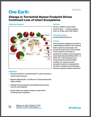
Human pressure mapping is important for understanding humanity’s role in shaping Earth’s patterns and processes. We provide the latest maps of the terrestrial human footprint and provide an assessment of change in human pressure across Earth. Between 2000 and 2013, 1.9 million km2 of land relatively free of human disturbance became highly modified. Our results show that humanity’s footprint is eroding Earth’s last intact ecosystems and that greater efforts are urgently needed to retain them.

Full Paper (Pdf)

Publication
Related page category(s)
Monitoring
Protected Area Network Design
Marine Planning
Data Analysis And Interpretation
A Changing Climate
Invasive Species
Marine & Terrestrial Waste
Related Pages
GBIF Metabarcoding Data Toolkit (MDT)
Biological Surveys of Carondelet, a Shallow, Submerged Seamount in the Phoenix Islands, Kiribati
Mapping the planet’s critical areas for biodiversity and nature’s contributions to people
Sustainable Finance for Asia and the Pacific: Protecting and Restoring Coral Reefs
High Seas Biodiversity Treaty Policy Brief
The Kunming-Montreal Global Biodiversity Framework: what it does and does not do, and how to improve it
Video - Introduction to SPREP's Regional Marine Species Programme
Video - Long Story Shorts: How Do Invasive Species Take Over?
Video - Long Story Shorts: Why Should You Care about Deep-Sea Mining?
The Marine Spatial Planning Index: a tool to guide and assess marine spatial planning

Latest News

NatGeo
The world’s lowest-lying islands are under threat—here’s how to make a…
March 10, 2026 by Isaac Rounds
Read More
Iris
Iris Prize
March 10, 2026 by Isaac Rounds
Read More
Restoration
EOCA Grants to Support Global Ecosystem Conservation and Restoration…
March 10, 2026 by Isaac Rounds
Read More
Vathe Conservation Area
Vanuatu - Concerns raised over breaches in Vathe Conservation Area
March 10, 2026 by Isaac Rounds
Read More

Latest Resources

The ‘Blue Pacific’: ocean governance and planetary health
March 10, 2026 by Isaac Rounds
Read More
Operationalizing nature recovery to market outcomes
March 6, 2026 by Isaac Rounds
Read More
Against the clock: Coral reefs demand a renaissance in discovery
March 6, 2026 by Isaac Rounds
Read More
Rethinking the 30 by 30 target to ensure the well-being of small-scale…
March 6, 2026 by Isaac Rounds
Read More
Biodiversity and Protected Areas Management Programme Logo Organisation of African, Caribbean and Pacific States Logo Sprep BioScapes Logo Flag of European Union International Union for Conservation of Nature Logo European Commission Logo

SPREP Footer Logo

A resilient Pacific environment sustaining our livelihoods and natural heritage in harmony with our cultures.

+685 21929
sprep@sprep.org

  • SPREP on Facebook
  • SPREP on YouTube
  • SPREP on Twitter
Protected Areas by Country
  • American Samoa
  • Cook Islands
  • Fiji
  • French Polynesia
  • Guam
  • Kiribati
  • Marshall Islands
  • Micronesia (Federated States of)
  • Nauru
  • New Caledonia
  • Niue
  • Northern Mariana Islands
  • Palau
  • Papua New Guinea
  • Samoa
  • Solomon Islands
  • Timor-Leste
  • Tokelau
  • Tonga
  • Tuvalu
  • Vanuatu
  • Wallis and Futuna
SPREP © 2026. All rights reserved.